


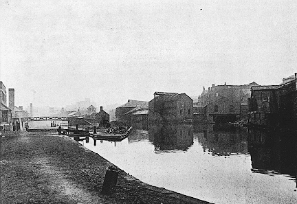
 Before 1750 Birmingham's
central position in Britain was a disadvantage. But then the canals were
built (See Picture). When finished in 1769 these were to highly beneficial
Birmingham's growth because heavy industry (for example steal manufacturing)
required vast amounts of coal, to melt the iron so that it could be fused
with other chemicals. Birmingham built its industry on iron, gun making
this would also need vast amounts of coal to melt the metal for moulding
(which would have probably been created nearby). Birmingham also was positioned
very close to the Black Country. This part of the country was rich in coal
and iron deposits. Birmingham was also positioned by the rivers Rea and
Tame these were important because heavy industry (especially metal) requires
water for their processes and the rivers for a type of free liquid rubbish
collection.
Before 1750 Birmingham's
central position in Britain was a disadvantage. But then the canals were
built (See Picture). When finished in 1769 these were to highly beneficial
Birmingham's growth because heavy industry (for example steal manufacturing)
required vast amounts of coal, to melt the iron so that it could be fused
with other chemicals. Birmingham built its industry on iron, gun making
this would also need vast amounts of coal to melt the metal for moulding
(which would have probably been created nearby). Birmingham also was positioned
very close to the Black Country. This part of the country was rich in coal
and iron deposits. Birmingham was also positioned by the rivers Rea and
Tame these were important because heavy industry (especially metal) requires
water for their processes and the rivers for a type of free liquid rubbish
collection.
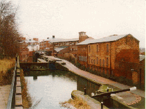 Today Birmingham's canal network is integral to city
centre redevelopment. Since the second world war the canals have been ignored.
Until the 1970s the full social potential was noticed. In the 1970s an ongoing
program was commissioned that was to change the face of Birmingham's canal
system. It was an instance of the Birmingham
City Council, the Department of the Environment and the British Waterways
Board all working together to the better city. In the 1980s the towpaths
were rebuilt and access to the canals was improved by the addition many
bridges and reopening of many pathways and access points. This program also
included cleaning the waters so that they could once again be used by long
boats, but this time they would not be captained by workers but by enthusiasts
and day trippers and no longer powered by horses but powered by diesel engines.
Today Birmingham's canal network is integral to city
centre redevelopment. Since the second world war the canals have been ignored.
Until the 1970s the full social potential was noticed. In the 1970s an ongoing
program was commissioned that was to change the face of Birmingham's canal
system. It was an instance of the Birmingham
City Council, the Department of the Environment and the British Waterways
Board all working together to the better city. In the 1980s the towpaths
were rebuilt and access to the canals was improved by the addition many
bridges and reopening of many pathways and access points. This program also
included cleaning the waters so that they could once again be used by long
boats, but this time they would not be captained by workers but by enthusiasts
and day trippers and no longer powered by horses but powered by diesel engines.